MTG Lightning Imager Accumulated Flash Radiance (AFR)
Access, exploration and visualization of MTG LI Accumulated Flash Radiance data using the Destination Earth Data Lake HDA service.
Contents
Objective: This notebook has the aim to show how to request the LI Accumulated Flash Radiance (AFR) product (
EO:EUM:DAT:0688), available through EUMETSAT and federated within the Destination Earth Data Lake.Data Sources: The notebook uses the LI Accumulated Flash Radiance (AFR) product
EO:EUM:DAT:0688, available through EUMETSAT and federated within the Destination Earth Data Lake.Methods: In this notebook, we demonstrate how to:
Authenticate to the Destination Earth Data Lake using the Harmonized Data Access (HDA) service.
Search for MTG Lightning Imager Accumulated Flash Radiance (AFR) products.
Download and extract the product structure.
Explore the structure of the product variables.
Convert the MTG geostationary coordinates into geographic latitude and longitude.
Visualize lightning activity using Cartopy and geospatial scatter plots.
Focus the analysis on a selected region over Northern Italy.
Prerequisites:
To search and access DEDL data a DestinE user account is needed
To search and access DT data an upgraded access is needed.
Expected Output:
1 AFR (Accumulated Flash Radiance) product archive containing the requested data,
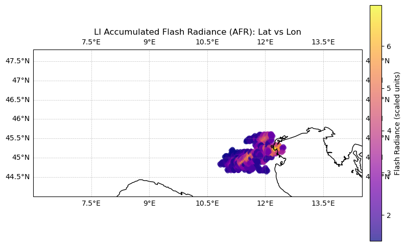
1 scatter plot of the Radiance Variable over Northern Italy on 21 July 2026. During this period, a powerful thunderstorm developed over the Po Valley and propagated towards the Adriatic Sea.
Setup
Let’s import useful packages
import destinelab as deauthimport requests
import json
import os
import zipfile
import datetime
import shutil
from getpass import getpass
import numpy as np
import pandas as pd
import xarray as xr
import matplotlib.pyplot as pltAuthenticate
Access to the Destination Earth Data Lake requires authentication using valid DESP credentials.
The authentication step retrieves a temporary access token that is subsequently used to authorize all requests to the HDA APIs. The token is included in the HTTP authorization header and enables secure access to metadata and data assets.
DESP_USERNAME = input("Please input your DESP username or email: ")
DESP_PASSWORD = getpass("Please input your DESP password: ")

auth = deauth.AuthHandler(DESP_USERNAME, DESP_PASSWORD)
access_token = auth.get_token()
if access_token is not None:
    print("DEDL/DESP Access Token Obtained Successfully")
else:
    print("Failed to Obtain DEDL/DESP Access Token")

auth_headers = {"Authorization": f"Bearer {access_token}"}
Please input your DESP username or email: eum-dedl-user
Please input your DESP password: ········
DEDL/DESP Access Token Obtained Successfully
Search for MTG Lightning Imager Products
The Harmonized Data Access (HDA) catalogue exposes datasets through a STAC-compliant interface.
In this example, we query the collection:
which corresponds to the EUMETSAT MTG Lightning Imager Accumulated Flash Radiance (AFR) product.
The temporal search window was selected to capture the severe convective event that affected Northern Italy on 21 July 2026. During this period, a powerful thunderstorm developed over the Po Valley and propagated towards the Adriatic Sea The AFR observations acquired between 10:10 UTC and 10:30 UTC provide an opportunity to investigate the lightning activity associated with this severe storm using the MTG Lightning Imager. The chosen time interval covers the mature phase of the convective system observed over Northern Italy.
The search returns a STAC item containing:
Product metadata
Download links
Product identifiers
Temporal coverage information
Associated NetCDF assets
HDA endpoint
HDA API is based on the Spatio Temporal Asset Catalog specification (STAC), it is convenient define a costant with its endpoint.
HDA_STAC_ENDPOINT="https://hda.data.destination-earth.eu/stac/v2"COLLECTION_ID = "EO.EUM.DAT.MTG.LI-AFR"response = requests.post(HDA_STAC_ENDPOINT+"/search", headers=auth_headers, json={
"collections": [COLLECTION_ID],
"datetime": "2026-07-21T10:10:00Z/2026-07-21T10:30:00Z"
})
if(response.status_code!= 200):
(print(response.text))
response.raise_for_status()from IPython.display import JSON
product = response.json()["features"][0]
#JSON(product)
print("Display the first result metadata:")
print(json.dumps(response.json()["features"][0], indent=4))Display the first result metadata:
{
"type": "Feature",
"assets": {
"EOPMetadata.xml": {
"href": "https://hda-download.eumetsat.data.destination-earth.eu/data/eumetsat/EO.EUM.DAT.MTG.LI-AFR/W_XX-EUMETSAT-Darmstadt%2CIMG%2BSAT%2CMTI1%2BLI-2-AFR--FD--x-x--ARC-x_C_EUMT_20260721103022_L2PF_OPE_20260721102000_20260721103000_N__O_0063_0000/EOPMetadata.xml",
"type": "application/xml",
"title": "EOPMetadata.xml",
"roles": [
"metadata"
],
"eumesat_ds:type": "Link",
"alternate": {
"origin": {
"href": "https://api.eumetsat.int/data/download/1.0.0/collections/EO%3AEUM%3ADAT%3A0688/products/W_XX-EUMETSAT-Darmstadt%2CIMG%2BSAT%2CMTI1%2BLI-2-AFR--FD--x-x--ARC-x_C_EUMT_20260721103022_L2PF_OPE_20260721102000_20260721103000_N__O_0063_0000/entry?name=EOPMetadata.xml",
"type": "application/xml",
"title": "EOPMetadata.xml",
"roles": [
"metadata"
],
"eumesat_ds:type": "Link"
}
}
},
"W_XX-EUMETSAT-Darmstadt,IMG+SAT,MTI1+LI-2-AFR--FD--CHK-BODY--ARC-NC4E_C_EUMT_20260721103022_L2PF_OPE_20260721102000_20260721103000_N__O_0063_0001.nc": {
"href": "https://hda-download.eumetsat.data.destination-earth.eu/data/eumetsat/EO.EUM.DAT.MTG.LI-AFR/W_XX-EUMETSAT-Darmstadt%2CIMG%2BSAT%2CMTI1%2BLI-2-AFR--FD--x-x--ARC-x_C_EUMT_20260721103022_L2PF_OPE_20260721102000_20260721103000_N__O_0063_0000/W_XX-EUMETSAT-Darmstadt%2CIMG%2BSAT%2CMTI1%2BLI-2-AFR--FD--CHK-BODY--ARC-NC4E_C_EUMT_20260721103022_L2PF_OPE_20260721102000_20260721103000_N__O_0063_0001.nc",
"type": "application/x-netcdf",
"title": "W_XX-EUMETSAT-Darmstadt,IMG+SAT,MTI1+LI-2-AFR--FD--CHK-BODY--ARC-NC4E_C_EUMT_20260721103022_L2PF_OPE_20260721102000_20260721103000_N__O_0063_0001.nc",
"roles": [
"data"
],
"eumesat_ds:type": "Link",
"alternate": {
"origin": {
"href": "https://api.eumetsat.int/data/download/1.0.0/collections/EO%3AEUM%3ADAT%3A0688/products/W_XX-EUMETSAT-Darmstadt%2CIMG%2BSAT%2CMTI1%2BLI-2-AFR--FD--x-x--ARC-x_C_EUMT_20260721103022_L2PF_OPE_20260721102000_20260721103000_N__O_0063_0000/entry?name=W_XX-EUMETSAT-Darmstadt%2CIMG%2BSAT%2CMTI1%2BLI-2-AFR--FD--CHK-BODY--ARC-NC4E_C_EUMT_20260721103022_L2PF_OPE_20260721102000_20260721103000_N__O_0063_0001.nc",
"type": "application/x-netcdf",
"title": "W_XX-EUMETSAT-Darmstadt,IMG+SAT,MTI1+LI-2-AFR--FD--CHK-BODY--ARC-NC4E_C_EUMT_20260721103022_L2PF_OPE_20260721102000_20260721103000_N__O_0063_0001.nc",
"roles": [
"data"
],
"eumesat_ds:type": "Link"
}
}
},
"W_XX-EUMETSAT-Darmstadt,IMG+SAT,MTI1+LI-2-AFR--FD--CHK-TRAIL--ARC-NC4E_C_EUMT_20260721103023_L2PF_OPE_20260721102000_20260721103000_N__O_0063_0002.nc": {
"href": "https://hda-download.eumetsat.data.destination-earth.eu/data/eumetsat/EO.EUM.DAT.MTG.LI-AFR/W_XX-EUMETSAT-Darmstadt%2CIMG%2BSAT%2CMTI1%2BLI-2-AFR--FD--x-x--ARC-x_C_EUMT_20260721103022_L2PF_OPE_20260721102000_20260721103000_N__O_0063_0000/W_XX-EUMETSAT-Darmstadt%2CIMG%2BSAT%2CMTI1%2BLI-2-AFR--FD--CHK-TRAIL--ARC-NC4E_C_EUMT_20260721103023_L2PF_OPE_20260721102000_20260721103000_N__O_0063_0002.nc",
"type": "application/x-netcdf",
"title": "W_XX-EUMETSAT-Darmstadt,IMG+SAT,MTI1+LI-2-AFR--FD--CHK-TRAIL--ARC-NC4E_C_EUMT_20260721103023_L2PF_OPE_20260721102000_20260721103000_N__O_0063_0002.nc",
"roles": [
"data"
],
"eumesat_ds:type": "Link",
"alternate": {
"origin": {
"href": "https://api.eumetsat.int/data/download/1.0.0/collections/EO%3AEUM%3ADAT%3A0688/products/W_XX-EUMETSAT-Darmstadt%2CIMG%2BSAT%2CMTI1%2BLI-2-AFR--FD--x-x--ARC-x_C_EUMT_20260721103022_L2PF_OPE_20260721102000_20260721103000_N__O_0063_0000/entry?name=W_XX-EUMETSAT-Darmstadt%2CIMG%2BSAT%2CMTI1%2BLI-2-AFR--FD--CHK-TRAIL--ARC-NC4E_C_EUMT_20260721103023_L2PF_OPE_20260721102000_20260721103000_N__O_0063_0002.nc",
"type": "application/x-netcdf",
"title": "W_XX-EUMETSAT-Darmstadt,IMG+SAT,MTI1+LI-2-AFR--FD--CHK-TRAIL--ARC-NC4E_C_EUMT_20260721103023_L2PF_OPE_20260721102000_20260721103000_N__O_0063_0002.nc",
"roles": [
"data"
],
"eumesat_ds:type": "Link"
}
}
},
"manifest.xml": {
"href": "https://hda-download.eumetsat.data.destination-earth.eu/data/eumetsat/EO.EUM.DAT.MTG.LI-AFR/W_XX-EUMETSAT-Darmstadt%2CIMG%2BSAT%2CMTI1%2BLI-2-AFR--FD--x-x--ARC-x_C_EUMT_20260721103022_L2PF_OPE_20260721102000_20260721103000_N__O_0063_0000/manifest.xml",
"type": "application/xml",
"title": "manifest.xml",
"roles": [
"metadata"
],
"eumesat_ds:type": "Link",
"alternate": {
"origin": {
"href": "https://api.eumetsat.int/data/download/1.0.0/collections/EO%3AEUM%3ADAT%3A0688/products/W_XX-EUMETSAT-Darmstadt%2CIMG%2BSAT%2CMTI1%2BLI-2-AFR--FD--x-x--ARC-x_C_EUMT_20260721103022_L2PF_OPE_20260721102000_20260721103000_N__O_0063_0000/entry?name=manifest.xml",
"type": "application/xml",
"title": "manifest.xml",
"roles": [
"metadata"
],
"eumesat_ds:type": "Link"
}
}
},
"downloadLink": {
"title": "Download link",
"href": "https://hda-download.eumetsat.data.destination-earth.eu/data/eumetsat/EO.EUM.DAT.MTG.LI-AFR/W_XX-EUMETSAT-Darmstadt%2CIMG%2BSAT%2CMTI1%2BLI-2-AFR--FD--x-x--ARC-x_C_EUMT_20260721103022_L2PF_OPE_20260721102000_20260721103000_N__O_0063_0000/downloadLink",
"type": "application/octet-stream",
"alternate": {
"origin": {
"title": "Origin asset link",
"href": "https://api.eumetsat.int/data/download/1.0.0/collections/EO%3AEUM%3ADAT%3A0688/products/W_XX-EUMETSAT-Darmstadt%2CIMG%2BSAT%2CMTI1%2BLI-2-AFR--FD--x-x--ARC-x_C_EUMT_20260721103022_L2PF_OPE_20260721102000_20260721103000_N__O_0063_0000",
"type": "application/octet-stream"
}
}
}
},
"id": "W_XX-EUMETSAT-Darmstadt,IMG+SAT,MTI1+LI-2-AFR--FD--x-x--ARC-x_C_EUMT_20260721103022_L2PF_OPE_20260721102000_20260721103000_N__O_0063_0000",
"geometry": {
"type": "Point",
"coordinates": [
0.0,
0.0
]
},
"bbox": [
0.0,
0.0,
0.0,
0.0
],
"collection": "EO.EUM.DAT.MTG.LI-AFR",
"stac_version": "1.1.0",
"properties": {
"datetime": "2026-07-21T10:20:00Z",
"end_datetime": "2026-07-21T10:30:00Z",
"instruments": [
"LI"
],
"platform": "MTI1",
"size": 272,
"start_datetime": "2026-07-21T10:20:00Z",
"title": "W_XX-EUMETSAT-Darmstadt_IMG_SAT_MTI1_LI-2-AFR--FD--x-x--ARC-x_C_EUMT_20260721103022_L2PF_OPE_20260721102000_20260721103000_N__O_0063_0000",
"uid": "W_XX-EUMETSAT-Darmstadt,IMG+SAT,MTI1+LI-2-AFR--FD--x-x--ARC-x_C_EUMT_20260721103022_L2PF_OPE_20260721102000_20260721103000_N__O_0063_0000",
"updated": "2026-07-21T10:30:48.396Z",
"eumetsat:links": {
"type": "Links",
"data": [
{
"type": "Link",
"href": "https://api.eumetsat.int/data/download/1.0.0/collections/EO%3AEUM%3ADAT%3A0688/products/W_XX-EUMETSAT-Darmstadt%2CIMG%2BSAT%2CMTI1%2BLI-2-AFR--FD--x-x--ARC-x_C_EUMT_20260721103022_L2PF_OPE_20260721102000_20260721103000_N__O_0063_0000",
"mediaType": "application/zip",
"title": "Product download"
}
],
"alternates": [
{
"type": "Link",
"href": "https://api.eumetsat.int/data/download/1.0.0/collections/EO%3AEUM%3ADAT%3A0688/products/W_XX-EUMETSAT-Darmstadt%2CIMG%2BSAT%2CMTI1%2BLI-2-AFR--FD--x-x--ARC-x_C_EUMT_20260721103022_L2PF_OPE_20260721102000_20260721103000_N__O_0063_0000/metadata",
"mediaType": "application/xml",
"title": "Metadata"
},
{
"type": "Link",
"href": "https://api.eumetsat.int/data/download/1.0.0/collections/EO%3AEUM%3ADAT%3A0688/products/W_XX-EUMETSAT-Darmstadt%2CIMG%2BSAT%2CMTI1%2BLI-2-AFR--FD--x-x--ARC-x_C_EUMT_20260721103022_L2PF_OPE_20260721102000_20260721103000_N__O_0063_0000/metadata?format=json",
"mediaType": "application/json",
"title": "Metadata in JSON format"
}
],
"sip-entries": [
{
"type": "Link",
"href": "https://api.eumetsat.int/data/download/1.0.0/collections/EO%3AEUM%3ADAT%3A0688/products/W_XX-EUMETSAT-Darmstadt%2CIMG%2BSAT%2CMTI1%2BLI-2-AFR--FD--x-x--ARC-x_C_EUMT_20260721103022_L2PF_OPE_20260721102000_20260721103000_N__O_0063_0000/entry?name=W_XX-EUMETSAT-Darmstadt%2CIMG%2BSAT%2CMTI1%2BLI-2-AFR--FD--CHK-BODY--ARC-NC4E_C_EUMT_20260721103022_L2PF_OPE_20260721102000_20260721103000_N__O_0063_0001.nc",
"mediaType": "application/x-netcdf",
"title": "W_XX-EUMETSAT-Darmstadt,IMG+SAT,MTI1+LI-2-AFR--FD--CHK-BODY--ARC-NC4E_C_EUMT_20260721103022_L2PF_OPE_20260721102000_20260721103000_N__O_0063_0001.nc"
},
{
"type": "Link",
"href": "https://api.eumetsat.int/data/download/1.0.0/collections/EO%3AEUM%3ADAT%3A0688/products/W_XX-EUMETSAT-Darmstadt%2CIMG%2BSAT%2CMTI1%2BLI-2-AFR--FD--x-x--ARC-x_C_EUMT_20260721103022_L2PF_OPE_20260721102000_20260721103000_N__O_0063_0000/entry?name=manifest.xml",
"mediaType": "application/xml",
"title": "manifest.xml"
},
{
"type": "Link",
"href": "https://api.eumetsat.int/data/download/1.0.0/collections/EO%3AEUM%3ADAT%3A0688/products/W_XX-EUMETSAT-Darmstadt%2CIMG%2BSAT%2CMTI1%2BLI-2-AFR--FD--x-x--ARC-x_C_EUMT_20260721103022_L2PF_OPE_20260721102000_20260721103000_N__O_0063_0000/entry?name=EOPMetadata.xml",
"mediaType": "application/xml",
"title": "EOPMetadata.xml"
},
{
"type": "Link",
"href": "https://api.eumetsat.int/data/download/1.0.0/collections/EO%3AEUM%3ADAT%3A0688/products/W_XX-EUMETSAT-Darmstadt%2CIMG%2BSAT%2CMTI1%2BLI-2-AFR--FD--x-x--ARC-x_C_EUMT_20260721103022_L2PF_OPE_20260721102000_20260721103000_N__O_0063_0000/entry?name=W_XX-EUMETSAT-Darmstadt%2CIMG%2BSAT%2CMTI1%2BLI-2-AFR--FD--CHK-TRAIL--ARC-NC4E_C_EUMT_20260721103023_L2PF_OPE_20260721102000_20260721103000_N__O_0063_0002.nc",
"mediaType": "application/x-netcdf",
"title": "W_XX-EUMETSAT-Darmstadt,IMG+SAT,MTI1+LI-2-AFR--FD--CHK-TRAIL--ARC-NC4E_C_EUMT_20260721103023_L2PF_OPE_20260721102000_20260721103000_N__O_0063_0002.nc"
}
]
},
"order:status": "succeeded",
"product:type": "MTILI2AFR",
"federation:backends": [
"eumetsat"
],
"providers": [
{
"name": "eumetsat",
"roles": [
"host"
]
}
]
},
"stac_extensions": [
"https://stac-extensions.github.io/order/v1.1.0/schema.json",
"https://stac-extensions.github.io/product/v1.0.0/schema.json"
],
"links": [
{
"rel": "collection",
"type": "application/json",
"href": "https://hda.data.destination-earth.eu/stac/v2/collections/EO.EUM.DAT.MTG.LI-AFR",
"title": "LI Accumulated Flash Radiance - MTG - 0 degree"
},
{
"rel": "self",
"type": "application/geo+json",
"href": "https://hda.data.destination-earth.eu/stac/v2/collections/EO.EUM.DAT.MTG.LI-AFR/items/W_XX-EUMETSAT-Darmstadt%2CIMG%2BSAT%2CMTI1%2BLI-2-AFR--FD--x-x--ARC-x_C_EUMT_20260721103022_L2PF_OPE_20260721102000_20260721103000_N__O_0063_0000",
"title": "Original item link"
}
]
}
Download the product archive
Each AFR product is distributed as a SIP file, a collection of NetCDF files and metadata documents.
The notebook retrieves the product archive using the download link provided in the STAC response and extracts its contents locally.
Typical AFR ((Accumulated Flash Radiance)) products contain:
Metadata files describing the product
A BODY NetCDF file containing the main measurements
A TRAIL NetCDF file containing additional information related to the accumulated lightning observations
from tqdm import tqdm
import time

from urllib.parse import unquote

workspace = 'data'
if not os.path.isdir(workspace):
    os.mkdir(workspace)

for asset in product["assets"]:
    download_url = product["assets"][asset]["href"]
    if asset != 'downloadLink':
        continue
    print(download_url)
    filename = workspace+'/'+unquote(download_url.split("/")[-2])
    print(filename)
    response = requests.get(download_url, headers=auth_headers)
    total_size = int(response.headers.get("content-length", 0))

    if os.path.exists(filename):
       print("The file exists.")
    else:
        print(f"downloading {filename}")

        with tqdm(total=total_size, unit="B", unit_scale=True) as progress_bar:
            with open(filename, 'wb') as f:
                for data in response.iter_content(1024):
                    progress_bar.update(len(data))
                    f.write(data)
    if asset == 'downloadLink':
        break;
https://hda-download.eumetsat.data.destination-earth.eu/data/eumetsat/EO.EUM.DAT.MTG.LI-AFR/W_XX-EUMETSAT-Darmstadt%2CIMG%2BSAT%2CMTI1%2BLI-2-AFR--FD--x-x--ARC-x_C_EUMT_20260721103022_L2PF_OPE_20260721102000_20260721103000_N__O_0063_0000/downloadLink
data/W_XX-EUMETSAT-Darmstadt,IMG+SAT,MTI1+LI-2-AFR--FD--x-x--ARC-x_C_EUMT_20260721103022_L2PF_OPE_20260721102000_20260721103000_N__O_0063_0000
The file exists.
zf=zipfile.ZipFile(filename)
with zipfile.ZipFile(filename, 'r') as zip_ref:
    zip_ref.extractall(workspace)
Explore the AFR (Accumulated Flash Radiance) Product Structure
The AFR product stores the lightning activity detected during the accumulation period.
Important variables include:
x: geostationary projection x coordinatey: geostationary projection y coordinateflash_radiance: accumulated lightning radiancemtg_geos_projection: information required to reconstruct the geostationary projection
Inspecting the dataset structure helps identify the variables required for geolocation and visualization.
from glob import glob

body_file = glob(workspace+"/*BODY*.nc")[0]
trail_file = glob(workspace+"/*TRAIL*.nc")[0]

print("BODY :", body_file)
print("TRAIL:", trail_file)
BODY : data/W_XX-EUMETSAT-Darmstadt,IMG+SAT,MTI1+LI-2-AFR--FD--CHK-BODY--ARC-NC4E_C_EUMT_20260721103022_L2PF_OPE_20260721102000_20260721103000_N__O_0063_0001.nc
TRAIL: data/W_XX-EUMETSAT-Darmstadt,IMG+SAT,MTI1+LI-2-AFR--FD--CHK-TRAIL--ARC-NC4E_C_EUMT_20260721103023_L2PF_OPE_20260721102000_20260721103000_N__O_0063_0002.nc
Inspect Available Variables
The following cells print all variables available in the dataset, together with their dimensions and metadata.
This step allows to understand:
The physical meaning of each variable
Units and coordinate systems
Data dimensions
Quality indicators and warning flags
ds = xr.open_dataset(body_file)

dsprint("\nVariables:")
for var in ds.data_vars:
print(f"\n===== {var} =====")
print(ds[var])
Variables:

===== auxiliary_dataset_identifier =====
<xarray.DataArray 'auxiliary_dataset_identifier' (auxiliary_dataset: 2)> Size: 400B
[2 values with dtype=<U50]
Dimensions without coordinates: auxiliary_dataset
Attributes:
    long_name:  Auxiliary dataset identifier
    title:      Identifier of auxiliary dataset or type of auxiliary dataset ...

===== auxiliary_dataset_status =====
<xarray.DataArray 'auxiliary_dataset_status' (auxiliary_dataset: 2)> Size: 2B
[2 values with dtype=int8]
Dimensions without coordinates: auxiliary_dataset
Attributes:
    long_name:  Status of auxiliary dataset
    meaning:    0 = OK, 1 = out_of_validity_time, 2 = not_available

===== mtg_geos_projection =====
<xarray.DataArray 'mtg_geos_projection' ()> Size: 4B
[1 values with dtype=int32]
Attributes:
    long_name:                       MTG geostationary projection
    grid_mapping_name:               geostationary
    perspective_point_height:        35786400.0
    semi_major_axis:                 6378137.0
    semi_minor_axis:                 6356752.31424518
    inverse_flattening:              298.257223563
    latitude_of_projection_origin:   0.0
    longitude_of_projection_origin:  0.0
    sweep_angle_axis:                y

===== accumulation_start_times =====
<xarray.DataArray 'accumulation_start_times' (accumulations: 20)> Size: 160B
[20 values with dtype=datetime64[ns]]
Dimensions without coordinates: accumulations
Attributes:
    long_name:  Accumulation start time
    precision:  0.001

===== accumulation_offsets =====
<xarray.DataArray 'accumulation_offsets' (accumulations: 20)> Size: 80B
[20 values with dtype=uint32]
Dimensions without coordinates: accumulations

===== x =====
<xarray.DataArray 'x' (pixels: 158943)> Size: 1MB
[158943 values with dtype=float64]
Dimensions without coordinates: pixels
Attributes:
    long_name:      azimuth angle encoded as column
    axis:           X
    units:          radian
    standard_name:  projection_x_coordinate
    valid_range:    [   1 5568]

===== y =====
<xarray.DataArray 'y' (pixels: 158943)> Size: 1MB
[158943 values with dtype=float64]
Dimensions without coordinates: pixels
Attributes:
    long_name:      Elevation angle encoded as row
    axis:           Y
    units:          radian
    standard_name:  projection_y_coordinate
    valid_range:    [   1 5568]

===== flash_radiance =====
<xarray.DataArray 'flash_radiance' (pixels: 158943)> Size: 636kB
[158943 values with dtype=float32]
Dimensions without coordinates: pixels
Attributes:
    long_name:     Area averaged flash radiance accumulation
    grid_mapping:  mtg_geos_projection
    coordinate:    sparse: x y
    units:         mW.m-2.sr-1

===== l1b_missing_warning =====
<xarray.DataArray 'l1b_missing_warning' (accumulations: 20)> Size: 20B
[20 values with dtype=int8]
Dimensions without coordinates: accumulations
Attributes:
    long_name:  Expected L1b inputs missing

===== l1b_geolocation_warning =====
<xarray.DataArray 'l1b_geolocation_warning' (accumulations: 20)> Size: 20B
[20 values with dtype=int8]
Dimensions without coordinates: accumulations
Attributes:
    long_name:  L1b event geolocation warning

===== l1b_radiometric_warning =====
<xarray.DataArray 'l1b_radiometric_warning' (accumulations: 20)> Size: 20B
[20 values with dtype=int8]
Dimensions without coordinates: accumulations
Attributes:
    long_name:  L1b event radiometric warning

===== average_flash_qa =====
<xarray.DataArray 'average_flash_qa' (accumulations: 20)> Size: 80B
[20 values with dtype=float32]
Dimensions without coordinates: accumulations
Attributes:
    long_name:  average flash confidence value
Identify the Radiance Variable
The AFR product contains the variable flash_radiance, which represents the accumulated optical radiance associated with lightning flashes detected by the Lightning Imager.
This variable is the primary quantity used throughout the remainder of the notebook for visualization and analysis.
rad_var_name=''
for var in ds.data_vars:
    if "radiance" in var.lower() or "afr" in var.lower():
        print(var)
        rad_var_name=var
flash_radiance
afr = ds[rad_var_name] Basic statistic
print(f"Min:  {float(afr.min())}")
print(f"Max:  {float(afr.max())}")
print(f"Mean: {float(afr.mean())}")
Min: 1.0
Max: 7170.0
Mean: 101.3907470703125
Geolocate Lightning Observations
The Lightning Imager measurements are stored in MTG geostationary projection coordinates.
To visualize the data on a geographic map, the projection coordinates (x, y) must be transformed into latitude and longitude using the geostationary projection parameters embedded in the product metadata.
After the transformation, each lightning observation can be represented as a georeferenced point and combined with other geospatial datasets.
The functions used below are adapted from the EUMETSAT MTG LI Data Access notebook and have been modified for the purposes of this demonstration.
def calculate_lat_lon(x, y):
    import warnings
    import numpy as np

    h = 42164.537
    r_eq = 6378.137
    r_p = 6356.752314

    """
    Calculate geodetic latitude and longitude in degrees from geostationary x, y coordinates.

    Args:
        x: Geostationary x-coordinate (radians).
        y: Geostationary y-coordinate (radians).

    Returns:
        Tuple (latitude, longitude) in degrees, or NaN if invalid.
    """
    try:
        s_4 = pow(r_eq, 2) / pow(r_p, 2)
        s_5 = pow(h, 2) - pow(r_eq, 2)

        # Suppress "invalid value encountered in sqrt" warnings
        with np.errstate(invalid='ignore'):
            s_d = np.sqrt(
                (h * np.cos(x) * np.cos(y))**2 -
                (np.cos(y) ** 2 + s_4 * np.sin(y) ** 2) * s_5
            )

        sn = (h * np.cos(x) * np.cos(y) - s_d) / \
             (np.cos(y) ** 2 + s_4 * np.sin(y) ** 2)
        s1 = h - sn * np.cos(x) * np.cos(y)
        s2 = -sn * np.sin(x) * np.cos(y)
        s3 = sn * np.sin(y)
        lat = np.degrees(np.arctan(s_4 * s3 / np.sqrt(s1 ** 2 + s2 ** 2)))
        lon = np.degrees(np.arctan(s2 / s1))
        return lat, lon
    except ValueError:
        return np.nan, np.nan
def safe_vectorized_calculate_lat_lon(x, y):
    lat_lon = np.vectorize(calculate_lat_lon)
    try:
        return lat_lon(x, y)
    except Exception as e:
        print(f"Error in lat/lon calculation: {e}")
        return np.full(x.shape, np.nan), np.full(y.shape, np.nan)
x = ds['x'][:]
y = ds['y'][:]latitudes, longitudes = safe_vectorized_calculate_lat_lon(x, y)Create a Geospatial DataFrame
The converted coordinates and radiance values are stored in a Pandas DataFrame.
This tabular representation simplifies:
Data filtering
Statistical analysis
Regional subsetting
Cartographic visualization
Each row corresponds to a geolocated lightning observation.
# create DataFrames
afr_radiance_df = pd.DataFrame({
    'x': x, 'y': y, 'latitude': latitudes, 'longitude': longitudes, 'flash_radiance': ds[rad_var_name][:]
}).dropna()
import matplotlib.pyplot as plt
import cartopy.crs as ccrs
import cartopy.feature as cfeature
def plot_lat_lon_scatter_coastlines(
dataframe,
title,
x_col='longitude',
y_col='latitude',
color_col=None,
color_label=None,
log_scale=False,
exclude_outliers=True,
cmap='viridis',
extent=None # [lon_min, lon_max, lat_min, lat_max]
):
"""
Scatter plot with coastlines using Cartopy.
Args:
dataframe: Pandas DataFrame containing data to plot.
title: Title of the plot.
x_col: Column name for x-axis values (default: 'longitude').
y_col: Column name for y-axis values (default: 'latitude').
color_col: Column name for color-coding the points.
color_label: Label for colorbar (optional).
log_scale: Whether to apply log scale to the color data.
exclude_outliers: Whether to exclude extreme outliers.
cmap: Colormap to use for scatter plot.
extent: Map extent as [lon_min, lon_max, lat_min, lat_max].
"""
if color_col and color_col in dataframe.columns:
data = dataframe[color_col]
# Exclude outliers based on percentiles
if exclude_outliers:
lower_bound = data.quantile(0.01)
upper_bound = data.quantile(0.99)
dataframe = dataframe[
(data >= lower_bound) & (data <= upper_bound)
]
# Apply log scale if required
color_data = (
np.log1p(dataframe[color_col])
if log_scale
else dataframe[color_col]
)
else:
color_data = None
fig = plt.figure(figsize=(10, 6))
ax = plt.axes(projection=ccrs.PlateCarree())
ax.set_title(title)
scatter = ax.scatter(
dataframe[x_col],
dataframe[y_col],
c=color_data,
cmap=cmap,
alpha=0.7,
transform=ccrs.PlateCarree()
)
# Add color bar if color_col is provided
if color_col:
cbar = plt.colorbar(scatter, ax=ax, orientation='vertical', pad=0.02)
cbar.set_label(color_label or color_col)
# Set map extent
if extent is not None:
ax.set_extent(extent, crs=ccrs.PlateCarree())
else:
ax.set_global()
# Add coastlines and gridlines
ax.add_feature(cfeature.COASTLINE, edgecolor='black')
ax.gridlines(
draw_labels=True,
linewidth=0.5,
color='gray',
alpha=0.5,
linestyle='--'
)
plt.show()Lightning Activity over Northern Italy
To better investigate the spatial distribution of lightning activity, the visualization is restricted to Northern Italy.
The map displays geolocated lightning observations coloured according to the accumulated flash radiance.
# Plot LI Accumulated Flash Radiance (AFR)
plot_lat_lon_scatter_coastlines(
    afr_radiance_df,
    title="LI Accumulated Flash Radiance (AFR): Lat vs Lon",
    x_col="longitude",
    y_col="latitude",
    color_col="flash_radiance",
    color_label="Flash Radiance (scaled units)",
    log_scale=True,  # log scaling
    exclude_outliers=True,  # filter out outliers
    cmap='plasma',  # plasma colormap
    extent=[6.0, 14.5, 44.0, 47.8]
)
Summary
This notebook demonstrated how to access and analyse MTG Lightning Imager Accumulated Flash Radiance data through the Destination Earth Data Lake.
Key steps included:
Authenticating with HDA services
Searching and downloading AFR products
Exploring the NetCDF data structure
Converting geostationary coordinates to latitude and longitude
Visualizing geolocated lightning observations
Investigating lightning activity over Northern Italy
The workflow can be extended to support other MTG Lightning Imager products and integrated with numerical weather prediction, satellite imagery, or severe weather monitoring applications.
Resources and References
This notebook demonstrates access, exploration and visualization of MTG Lightning Imager (LI) Accumulated Flash Radiance (AFR) products through the Destination Earth Data Lake using the Harmonized Data Access (HDA) service.
Data: MTG Lightning Imager Accumulated Flash Radiance (AFR) EUMETSAT Data Store Product: [EO:EUM:DAT:0688]
Documentation and Example Notebooks
[EUMETSAT MTG Lightning Imager Data Access Example] (https://
Acknowledgements Parts of the data access and geolocation workflow were inspired by or adapted from the EUMETSAT example notebook MTG LI Data Access.